


Mappt
GIS Data Collection
Περιγραφή του Mappt: GIS Data Collection
Mappt ™ είναι ένα ισχυρό GIS (Γεωγραφικό Σύστημα Πληροφοριών) app συλλογής δεδομένων που επιτρέπει στους χρήστες να δημιουργήσουν, τα δεδομένα που βασίζονται στην τοποθεσία επεξεργασία, αποθήκευση και κοινή χρήση με ένα ελαφρύ, συμπαγή συσκευή.
Mappt ™ χρησιμοποιείται σε βιομηχανίες που εκτείνονται από τις περιβαλλοντικές και τη γεωργία, την εξόρυξη και την τοπική αυτοδιοίκηση σε πάνω από 130 χώρες σε όλο τον κόσμο.
Επιλέγουν Mappt ™ επειδή ενσωματώνει με δημοφιλή GIS επιφάνεια εργασίας συμπεριλαμβανομένων των ArcGIS και QGIS, και οι φιλική προς το χρήστη διεπαφή οικοδεσπότες εύκολο στη χρήση χαρακτηριστικά ότι ακόμη και τα νέα για τη συλλογή δεδομένων πεδίου θα κυριαρχήσει σε λίγα λεπτά, μεταξύ των οποίων:
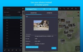
- γεωσήμανση φωτογραφίες για να δώσουν σημαντικά στοιχεία σας ένα πολύ πιο οπτικό στοιχείο από ένα σημείο δείκτη
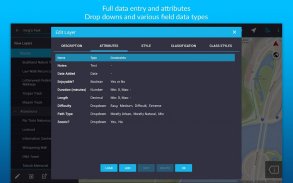
- Πέσε κάτω έντυπα για ταχύτερη συλλογή δεδομένων
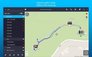
- Εκτός σύνδεσης εντοπισμού GPS
- Επί της οθόνης εργαλεία σχολιασμού για να σχεδιάσετε, να προσθέσετε κείμενο και να δημιουργήσετε σχήματα πάνω από τα δεδομένα σας
- Διαβάστε και κατεβάστε μια πλήρη σουίτα WMS / WFS & WMTS σύνολα δεδομένων
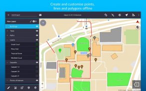
- Τα σημεία, πολύγωνα και πολύγραμμα
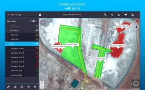
- δυνατότητες Geofencing βεβαιωθείτε ότι έχετε ποτέ δεν παραβιάζουν το όριο,
- Επικάλυψη συντονίζει δίκτυα δείτε την ακριβή απόσταση μεταξύ των περιοχών
- Λειτουργία προβολής δρόμου με σχολιασμούς επί της οθόνης διαθέσιμη
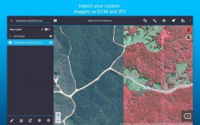
- Δυνατότητα εισαγωγής απεριόριστου μεγέθους δορυφόρος, εναέρια, γεωλογικά, τοπογραφικά, ανάδειξη και άλλων τύπων εικόνων στο ECW και JP2 μορφή
- Εισαγωγή και εξαγωγή δημοφιλείς μορφές GIS όπως Shapefiles, JP2 και KML / KMZ
- Κοινή χρήση των δεδομένων σας από δημοφιλή αποθήκευσης cloud, όπως το Google Drive
Οι πελάτες μας έχουν χρησιμοποιήσει την εφαρμογή offline GIS μας για μια σειρά στο πεδίο των καθηκόντων μεταξύ των οποίων:
- χαρτογράφηση πεδίο
- Τοπογραφικές εργασίες
- τη διαχείριση της βλάστησης
- σχεδιασμός Δασών
- Περιβαλλοντική διαχείρηση
- αναφορές περιστατικών
- η διαχείριση των εξορυκτικών
- χαρτογράφηση Farm
- χαρτογράφηση Utility
- σχεδιασμός κυβέρνηση
- Διαχείριση περιουσιακών στοιχείων
Αφήστε τις ανησυχίες internet, ογκώδη εξοπλισμό και ανακριβή στοιχεία κατά το παρελθόν, και να ζήσετε μια πιο αποτελεσματική μέλλον της συλλογής δεδομένων με Mappt ™.
*** ΣΗΜΕΙΩΣΗ: Είστε ελεύθεροι σε δίκη Mappt ™ για 120 λεπτά. Μόλις αυτή τη φορά είναι επάνω, μπορείτε είτε να περιμένετε 8 ωρών για άλλα 120 λεπτά, ή να αγοράσετε μια μηνιαία άδεια από US $ 29 έως ξεκλειδώσετε την πλήρη λειτουργικότητα. Για περισσότερες πληροφορίες σχετικά με τις δυνατότητες και τα επίπεδα αδειοδότησης, παρακαλούμε επισκεφθείτε www.mappt.com.au/pricing.***
Mappt: GIS Data Collection - Έκδοση 3.14.0
(22-01-2025)Mappt: GIS Data Collection - Πληροφορίες APK
Έκδοση APK: 3.14.0Πακέτο: au.com.mapptΤελευταία έκδοση του Mappt: GIS Data Collection
Άλλες εκδόσεις


Εφαρμογές στην ίδια κατηγορία

Μπορεί επίσης να σου αρέσουν...


